


- Melinda Daniels
- Presenter’s NSFRESOURCECENTERS
- Stroud Water Research Center
- Anthony Aufdenkampe
- http://www.stroudcenter.org/about/aufdenkampe.shtm
- Associate Research Scientist
- Presenter’s NSFRESOURCECENTERS
- Stroud Water Research Center
- Steve Kerlin
- http://www.stroudcenter.org/about/stevenkerlin.shtm
- Director of Education
- Presenter’s NSFRESOURCECENTERS
- Stroud Water Research Center
- Nanette Marcum-Dietrich
- http://concord.org/projects/teaching-environmental-sustainability
- Teaching Environmental Sustainability - Model My Watershed
- Presenter’s NSFRESOURCECENTERS
- Millersville University of Pennsylvania
- Carolyn Staudt
- https://concord.org/about/staff/carolyn-staudt
- Curriculum/Professional Developer
- Presenter’s NSFRESOURCECENTERS
- Concord Consortium
Teaching Environmental Sustainability with Model My Watershed
NSF Awards: 1418133
2016 (see original presentation & discussion)
Grades 6-8, Grades 9-12
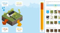
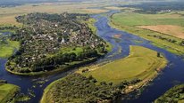
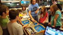
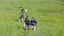
The overall goal of the project is to develop an interdisciplinary, place-based, problem-based, hands-on set of resources, models and tools (RMTs) aligned to the Next Generation Science Standards to promote geospatial literacy and systems thinking. The project’s web applications, probeware and curricula are developed for middle and high school students to introduce them to environmental and geospatial science that will engender critical incidents, thus encouraging students to pursue environmental and geoscience careers. The project has developed a web application, Model My Watershed (MMW), consisting of interactive, geographic information systems (GIS) and hydrological modeling tools that are scientifically accurate and allows users to easily assess and analyze complex national databases of environmental conditions in their local watersheds and also allows them to make virtual modifications to the environment to reduce both stormwater runoff and to improve water quality. The project has also developed a low-cost device, the Watershed Tracker, that consists of four probes with Bluetooth connectivity that can run on both Android and Apple devices without the need for additional hardware or software. In addition, this project has developed draft curriculum and is providing teacher professional development in five states (CA, IA, KS, PA, VA). Although the targeted watersheds are in those five states, the MMW application covers the contiguous 48 states and is freely available to anyone wishing to use it.
Related Content for Teaching Environmental Sustainability
-
 2018Watershed Modeling and Schoolyard Investigations
Steve Kerlin
-
 2015Teaching Environmental Sustainability
Nanette Marcum-Dietrich
-
 2022Community Science Investigations for Social Justice
Kevin Cuff
-
 2019Seeding the Future with Change Makers
Rajeev Rupani
-
 2019Agricultural Applications of Computer Science
Joseph Kern
-
 2019Carbon TIME: A Research-Practice Partnership Project
Charles Anderson
-
 2022Science Strikes Back!
Robert Hougham
-
 2022Urban Environmental Stewards: Youth Aid Community with STEM
Connie Flanagan
Richard Hudson
Senior Executive Producer
The video introduces a set of powerful tools for watershed inquiry. Can you share any specific student projects and experiences so far? What grade level are you designing for?
Carolyn Staudt
Curriculum/Professional Developer
Richard, This project is working in five research states (CA, IA, KS,PA, and VA) in both middle school and high school classrooms. We are just finishing the initial year of implementation in a total of seventy classrooms throughout these states. In these research states we are collecting data from the Innovative Technology in Science Inquiry portal. However, the Teaching Environmental Sustainability: Model My Watershed portal activities (https://itsi.portal.concord.org/itsi#high-schoo...) are open for any middle school or high school teacher to use. The tools are embedded in the activities and student reports are available for teachers to view once they assign them to their students. The activities have been written for ninth grade implementation, but the portal provides a way for teachers to customize their activities to fit their particular curriculum, student reading level and local needs. Once a teacher signs into the portal (https://itsi.portal.concord.org/), they can use the help support (https://itsi.portal.concord.org/help) to sign in their students and customize the exemplar activities. Carolyn
Richard Hudson
Senior Executive Producer
I’m sure the STEMforAll community here would enjoy any preliminary findings you might be willing to share. The use of hand-held and other software tools for environmental investigations is almost a field unto itself, worthy of further study. (such as Fieldscope, Project Noah, Active Explorer from the AAAS).
araina boyd
This project is fantastic! I am happy to see this program is available for both Android and Apple devices. I could see this program used in after school STEM programs or possibly at a STEM camp. Is there curriculum designed for short term and long term applications?
Carolyn Staudt
Curriculum/Professional Developer
Ariana, Great question! We are hoping that the student investigations into their local schoolyards parlay into investigations and actions in their local neighborhoods. We hope student’s engagement with the models and the Watershed Tracker around conservation practices extend outside the classroom and into their personal lives. The research on Critical Incidence (CI) (https://concord.org/projects/teaching-environme...) will help us track their use of the resource, models and tools (RMTs) outside of class. Carolyn
Noell Hyman
Am I right to understand that these tools (or at least the mapping ones) only work for the states in which you’re researching (CA, IA, KS, PA, VA)? I am in AZ and tried the watershed map. I was able to find our location on the map but I couldn’t find a way to identify our watershed boundaries. I’m not sure i it’s because I don’t understand the map, or because it’s not set up for our area.
Carolyn Staudt
Curriculum/Professional Developer
Noell, The watershed models work for the lower 48 states. You can view the Teaching Environmental Sustainability: Model My Watershed activities at https://itsi.portal.concord.org/itsi#high-schoo.... Both the Micro Site Storm model (https://guides.itsi.concord.org/tes-mmw-teacher...) and full Site Storm model (https://guides.itsi.concord.org/tes-mmw-teacher...) are embedded in the activities. The guides listed above show how the models will allow you to access the USGS National Land Cover database information for your location. Carolyn
Jerry Valadez
CEO
Carolyn, great video! As I am the coordinator for the California site I am coming into this conversation with a little bias. However, the video here does a great job of showcasing the project. Mostly classroom teachers have participated so far but this coming summer I will be using TES:MMW with a summer class in a rural city in the San Joaquin Valley. Our experience with TES:MMW shows good opportunity for English Learners as well to develop a better understanding of English in the context of the TES:MMW curriculum. We add a trip to the local river for riparian ecology and habitat studies and data collection using the TES:MMW probes, and incorporate the actual data into their use of the online models and curriculum.
We are recruiting for the new cohort this summer so if you know any middle school or high school teachers out this way in California please let them know.
Thank you.
Carolyn Staudt
Curriculum/Professional Developer
Jerry, great to hear your voice from Central Valley in CA, one of our research sites. Having a wide variety of diverse locations has added to our research. All locations in the lower 48 states can use this curriculum and have students investigate their local watersheds and suggest great conservation practices.
May Jadallah
Fascinating project. How do you define systems thinking given that it is defined differently by different people?
Nanette Marcum-Dietrich
Teaching Environmental Sustainability - Model My Watershed
Hi May – Great question.
Systems thinking recognizes the complexity and interdependency of dynamic systems and how these system influence each other. It is through a better understanding of these systems that we can identify innovative solutions to complex and “messy” problems. Watersheds are indeed complex and dynamic systems!
Stroud Water Research Center is a pioneer in understanding this concept. Visit http://www.stroudcenter.org/about/portrait/cont... to learn more about the River Continuum Concept.
Here is an excerpt-
A river is more than the sum of its parts, Vannote asserted. It is not a static body of water. It is a single continuum that flows ceaselessly from its source to the sea. To understand what is happening at any point along the way, you must understand both what is happening upstream and what is entering from the watershed.
The River Continuum Concept was the first unified hypothesis about how streams and their watersheds work. It dominated river studies for the next decade, and it established Stroud Water Research Center as a pioneer in innovative research
Kathryn Quigley
What an inspiring project! Its amazing to think about kids working on real geospatial data for earth science – I didn’t work on anything like that till college. Looks like the activity mirrors the real work flow that many earth scientist do with satellite data analisys and modeling
Nanette Marcum-Dietrich
Teaching Environmental Sustainability - Model My Watershed
Hi Kathryn – Thank you for the kind words. The goal of the project from the start was to provide students with access to “real science.” This required the use of REAL data, REAL tools, REAL models, REAL places so that students can make informed decisions about their environment. Scientists from the Stroud Water Research Center led the development of the Model My Watershed Application which is intended to be used by students and watershed professionals. If you are interested in more tools developed by Stroud check out http://wikiwatershed.org/
Robert Tinker
Water monitoring projects have been used for decades, but one huge problem is going beyond simply measuring water quality. This project provides a very convincing context for measurements using powerful technologies. I’d be interested in hearing more about the connections between the water quality measurements and the mapping studies.
Dilafruz Williams
It is indeed exciting to see the wonderful ways in which students are engaged and involved! You state that the project is in five states (CA, IA, KS,PA, and VA) in both middle school and high school classrooms. Are you finding differences middle and high school students’ responses to the project? Also, since there is an amazing body of writing on place-based education, I was wondering if you could speak to whether students are sharing their sense of connectedness to their own place and locale because of this project? And, do you notice any differences among students’ expressions/understandings by states? Thank you for sharing this amazing model.
Nanette Marcum-Dietrich
Teaching Environmental Sustainability - Model My Watershed
Dr. Williams –
Great Questions! We are in year one of implementation. Teachers are using the project this spring in their classrooms and we are currently collecting data that will speak to these questions. The data analysis won’t begin until summer but we hope to have something to share at AERA and NARST in 2017.
Further posting is closed as the event has ended.