


- John Moore
- Executive Director
- Presenter’s NSFRESOURCECENTERS
- GLOBE Mission Earth
- Sriram Elango
- https://www.linkedin.com/in/sriram-e-a55b561b4/
- Student Intern
- Presenter’s NSFRESOURCECENTERS
- Institute for Earth Observations
- Maxwell Friedman
- Student Intern
- Presenter’s NSFRESOURCECENTERS
- Institute for Earth Observations
GLOBE Mission Earth: Fusing GLOBE with NASA assets to build systematic innova...
NNX16AC54A
2022 (see original presentation & discussion)
All Age Groups
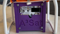
The A3Sat project allows students to build an active model mirroring many aspects of an authentic CubeSat design engineers use for launch into space.
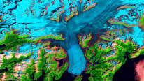
A3Sat has been programed to send data and imagery to a designed ground station replicating collection and transmission of data. The app is a desktop software application, compatible with both macOS and Windows, and is able to communicate and transfer various data through Python socket communication. Students are able to pair the A3Sat and the computer through a WIFI hotspot from the Raspberry Pi, and further control the A3Sat from the app while also viewing real-time environmental data, health data (CPU intensity, etc.), as well as infrared and regular images. Built within the Ground Station app are data analysis and visualization tools, such as data plotting of all environmental data, as well as a 3D graph visualization of the altitude/displacement of the A3Sat. Students are able to conduct data analysis while the A3Sat is still in flight, viewing data stream into the app while also being plotted live within both the 3D visualization as well as the various graphs. In order to enable greater data analysis and promote data literacy within students, the app allows users to export Excel files of the data collected, allowing them to apply the data in the context of other purposes.
A3Sat has been identified as a "Tier 1" spacecraft simulator, and is currently being used as part of a 3-Tier Pedagogy and Space Workforce Development
Related Content for Earth SySTEM: Using Satellites to Monitor the Earth
-
 2021A3Sat: To Observe the Earth and Visualize the Future
John Moore
-
 2022Engaging the Public in S.T.E.A.M with Landsat
Peder Nelson
-
 2019GLOBE Mission EARTH: Inspiring Tomorrow's STEM Professionals
Sara Mierzwiak
-
 2020GLOBE Mission EARTH: Inspiring tomorrow's STEM Professionals
Sara Mierzwiak
-
 2018GLOBE Mission EARTH: Engaging Students in Authentic Science
Kevin Czajkowski
-
 2020Connecting Students to Earth SySTEM through Mixed Realities
John Moore
-
 2018NASA STEM Enhancement in Earth Science H.S. Internship
Margaret Baguio
-
 2019Participatory research on fisheries in tropical rivers
Renato Silvano
Stephen Uzzo
Chief Scientist
If I understand this project correctly, you are using drones to launch CubeSats to gather data and there is a dashboard on computers that controls and monitors the CubeSat as part of a simulator for a space-based CubeSat vehicle. If this is an accurate characterization of the technology you have developed I would see great potential for it to be used for airborne imaging and analysis and a whole new dimension of possibilities for citizen science. Have you worked with teachers and students yet to develop PD programs, curriculum and classroom activities? The potential of this technology is immense and wondering about your plans to scale and make it more widely available for learning communities.
John Moore
Executive Director
Greetings and thank you for your comments. Both the CubeSat Model and the Ground Station were developed by high school students. The A3Sat model has been vetted by Dr. Jin Kang, US Naval Academy Director of Satellites, and Professor Twiggs as to its authenticity and representation of building space-ready CubeSats. The curriculum building has started particularly in the engineering design practices. Video assembling instructions etc. are available though us as part of the project. Since the design was focused on environmental oriented data and imagery, we have applications that compare ground data using the GLOBE Observer app and that received from flight. Our design was also directed by testing flight requirements to create a 30m pixel thus mirroring a LandSat Pixel. GLOBE also has Land Cover and pixel analysis protocols in place that are a part of the applications. We have worked with a groups of high schools (teachers and students) in pilot testing and are making plans to promote as an authentic STEM program. Thank you for your vote of confidence as to the future, that is very meaningful to us!
John Moore
Executive Director
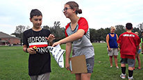
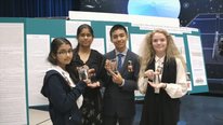
Welcome to the A3Sat Project. CubeSats have been playing ever increasing contributions to the aerospace community. For several years University projects have worked on CubeSat projects and launched their satellites. If CubeSats continue to play critical roles in the future of satellites, precollege students need to be exposed not only to the technologies involved, or the simple fact that these academic and career pathways exist. While there are many STEM programs and projects in pre-college schools, this project represents an authentic STEM opportunity for students that is affordable to the K12 community. The focus of this presentation is on the development of the "Ground Station" that will transmit data and imagery in real time. It is important to note that the entire engineering design and build process, including all of the coding for the A3Sat, and the entire Ground Station app was accomplished by high school students who are co-presenters with me this year. Currently through GLOBE Mission earth, there has been 10 "kits" distributed to various K12 schools and/or programs to evaluate the build process and success of the transmission of data and imagery.
George Hein
Professor Emeritus
Thank you for tis additional information. I can see that this technology can be useful for a wide range of school projects. I wonder how far down the age range it can be useful? Analyzing data from your own community is always a winner with children (and adults).
John Moore
Executive Director
We have examples of students in the middle school range working on this project. We are also trying to make the case of the value of comparing ground observations to those of Earth Observing Satellites. The GLOBE Program offers many applications of that, the TREES Project compares that data to ICESat2, CLOUDS to NOAA /NASA satellites, and Landcover to LandSat. It is our mission to combine those skills and experiences of being out in the environment (field studies) to the technologies of satellites and remote sensing (providing a global perspective to students). In addition, it has been my experience that if you discover a student's passion for a particular subject it opens learning up to another level. In this approach we can have both environmental (outdoors) oriented students, work together with computer science, coding, and technological students working TOGETHER on common investigations … this is what NSF refers to as coming out of your "silos. Good for the future workforce. Ultimate goal, to broaden participation!
George Hein
Professor Emeritus
Thanks for your note. I agree that "if you discover a student's passion for a particular subject it opens learning up to another level". And students of all ages are interested in things they see and experience daily and are nearby. They don't necessarily like them, but they know them. I can imagine all sorts of explorations as these images are increasingly available.
Folashade Solomon
Associate Professor
As the students learn to build models and analyze data, what are the common skills you have to teach your students? What skills do they seem to take with them as a result of their engagement in the project?
John Moore
Executive Director
Thank you for commenting, the entire "engineering design" process is taught, coding, 3D printing, some basic electronics (wiring diagrams etc.). Once the data and/or imagery is gathered via the Ground Station we are investigating atmospheric conditions, and with the imagery doing image analysis. Using protocol from the GLOBE Observer app, we are able to compare ground truth data to that acquired through remote sensing. Thus it also opens the door for students to learn about Earth Observing Satellites and he important data/imagery that they acquire. A major goal is to introduce the role of the world of satellites and remote sensing (especially CubeSats) to mainstream K12 students in an effort to broaden participation in the field of the Geosciences and/or Aerospace Science, Students need to be exposed to these career pathways while in the K12 environment.
Folashade Solomon
Associate Professor
I agree. Thanks
Dave Chapman
As always, John, you have given students wonderful experiences that will change their lives.
John Moore
Executive Director
Thank you David. It is wonderful to see students step to these challenges as well. I do hope these types of opportunities fosters thinking that opens up a world of new possibilities in their futures.
John Ristvey
Hi John,
Great video and project! Have you encountered any issues with using drones for data collection? If so, how have you overcome these challenges? Or what other challenges have you and your team overcome?
John Moore
Executive Director
The drones have not been an issue. Max, among his skillset is, he has very good experience with drones. To your point, this may be an issues with teachers or administrators the idea of flying the A3Sat with drones. We have experimented with tethered balloons, and have developed an attachment for the NASA Aerokats, Flying kites may sound like it is an easy route, but "large" kite flying is actually quite challenging. Good news is that you have the fine folks of the Aerokat Project to guide you through any potential hurdles.
Creating the Ground Station created a challenge because Sriram started from scratch to develop the program. Fortunately, he is very talented. However, it speaks to the conversations that have been online in other videos to the point of what students are actually capable of achieving when given the opportunity. From an educational viewpoint, it is great to students engaged with "authentic STEM" and experiences collaborative efforts that are required as part of the project. Thanks John for you comments!
Robert Richards
Hi John, Great video and project! My students and I have truly enjoyed working with the A3Sat. As the project progresses we look forward to more collaboration with you and your students. My students will be working with younger students in the fall helping them to build the A3Sat while working towards a suborbital launch of their own cubeSat. We are hoping to conduct educational outreach with our friends in the Pacific using the A3Sat and our new curriculum tools. Once again Great Project and thank you for getting us started.
John Moore
Executive Director
Thanks you Robert. Your students are doing an amazing job and we congratulate them. You and your class are proving the point that this project is an important aspect to STEM and is developing skills well beyond what students generally have access to, all while learning workforce readiness skills!
Autumn Burdick
Really nice to see this hands-on-learning in action. And this project is a perfect example of S-T-E-M! Well done, students!
Marta Kingsland
Great example about STEM! Congratulations
Further posting is closed as the event has ended.