


- Peder Nelson
- https://www.linkedin.com/in/peder-nelson-99ab04a0/
- OregonView State Coordinator, Land Cover Science Lead for GLOBE Observer, Sr. Faculty Research Assistant, Sr. Instructor of Geography and Geospatial Sciences
- Presenter’s NSFRESOURCECENTERS
- Oregon State University, AmericaView
- Claudia Bolaños
- https://www.cjbolanos.com
- NASA Intern, Landsat Multimedia Outreach Developer
- Presenter’s NSFRESOURCECENTERS
- George Mason University, NASA Goddard Space Flight Center
- Ginger Butcher
- https://www.linkedin.com/in/gingerbutcher/
- Communication and Public Engagement Lead
- Presenter’s NSFRESOURCECENTERS
- NASA Goddard Space Flight Center, Science Systems and Applications Inc
- Christopher McGinty
- https://www.linkedin.com/in/chrismcginty/
- Executive Director
- Presenter’s NSFRESOURCECENTERS
- AmericaView
- Lisa Wirth
- Program Director
- Presenter’s NSFRESOURCECENTERS
- AmericaView
AmericaView
G18AP00077
2022 (see original presentation & discussion)
Grades 6-8, Grades 9-12, Undergraduate, Adult learners, Informal, All Age Groups
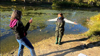
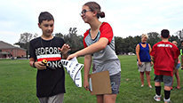
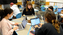
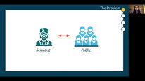
In this video, we highlight how public science has been transformed through 50 years of Earth Observations with the Landsat satellites that started in the summer of 1972. We share how you can connect this unique data through citizen science, education activities, and community participation in the science of mapping, measuring, and monitoring our home planet. AmericaView and it's membership have been leaders in sharing knowledge about remote sensing technology, career pathways, and providing opportunities to create generational understanding of the ecological processes shaping our lives. A connection with the NASA supported GLOBE Observer mobile app will be shared as a way to contribute your own observations to the science and education data set that can support space-based Earth Observations.
Related Content for Engaging the Public in S.T.E.A.M with Landsat
-
 2021GLOBE Mission EARTH: GLOBE in the Time of COVID
Sara Mierzwiak
-
 2021WeatherBlur: student initiated citizen science program
Rebecca Clark Uchenna
-
 2019GLOBE Mission EARTH: Inspiring Tomorrow's STEM Professionals
Sara Mierzwiak
-
 2017THE CROWD & THE CLOUD trailer
Geoff Haines-Stiles
-
 2022MindHive: Citizen Science in the High School Classroom
Lucy Yetman-Michaelson
-
 2021MindHive: A Citizen Science Platform
Sushmita Sadhukha
-
 2021Virtual Citizen Science Expo
Nicole Colston
-
 2021Understanding the Role of Intermediaries in Citizen Science
Haley Smith
Christopher McGinty
Executive Director
Welcome and thank you for watching our STEM (or STEAM, STEM + ART) video. We look forward to your comments and discussion! For additional information about AmericaView and free STEAM resources, please visit our website!
Justice Walker
Ana Prieto
Peder Nelson
OregonView State Coordinator, Land Cover Science Lead for GLOBE Observer, Sr. Faculty Research Assistant, Sr. Instructor of Geography and Geospatial Sciences
As an educator and scientist, I am excited to talk to you about how you can be part of #GenerationalScience with Landsat.
Did you know that this year is the 50th anniversary of monitoring Earth from space for the benefit of all? You can learn more about what it took to achieve this landmark through the great resources by the U.S. Geological Survey (USGS) and the National Aeronatics and Space Administration (NASA) who jointly manage the satellites, data, science, and education.
Ways you can be involved:
As we say at AmericaView...."Everyday is Earth Observation Day" and we invite you to share your observations for the benefit of all current and future Earthlings.
Christopher McGinty
Justice Walker
Ana Prieto
Kevin Czajkowski
Great video. Has there been research into how well the games help students learn about the Landsat Program?
Christopher McGinty
Claudia Bolaños
Ana Prieto
Christopher McGinty
Executive Director
Kevin, We haven't done much in the way of research with students or teachers and how it has helped. We know from talking with teachers, after the fact, that the games are well received. We could (and should) look at conducting some research to better understand the use and effectiveness. Great comment!
Ana Prieto
This is a wonderful project that allowed us to learn and investigate together with our students.
Congratulations!
Christopher McGinty
Claudia Bolaños
Christopher McGinty
Executive Director
Thank you, Ana! We appreciate you taking the time to watch and comment!
James Callahan
Such a beautiful video. Granted, you have an incredibly rich treasure chest of images to draw from. Landsat has always been amazing, and continues to be. Still this video is so well done.
Checking in. Have you been staying in touch with the staff at CLEAN of late? That's the enormous and very influential resource library, primarily for K-12 teachers and schools. Looking at the Earth with an emphasis on climate change and resiliency. Keeping that connection active and robust is highly recommended
Landsat never gets old. In my opinion, it will be quite appropriate for the CLEAN Network to update how it is promoting your program and resources.
Thank you for this marvelous contribution to the 2022 Showcase!
Christopher McGinty
Claudia Bolaños
Justice Walker
Christopher McGinty
Executive Director
James, thank you! Yes, we had a great number of media resources, satellite imagery, and experiences to draw from for the video. We have not been in touch with the staff at CLEAN - but we clearly need to be! Thank you for the suggestion. We appreciate your comments!
Jay Labov
Currently STEM Education Consultant
Thank you for submitting this video. Landsat has so much potential to improve STEAM education for people of all ages and backgrounds. Based on my own experience on improving STEM education through my previous work at the National Academies of Sciences, Engineering, and Medicine, I hope you can address some of the following questions that occurred to me as I watched the video:
“The Integration of the Humanities and Arts with Sciences, Engineering, and Medicine in Higher Education: Branches from the Same Tree.” 2018. https://www.nap.edu/catalog/24988.
Thank you again for making these resources publicly available!
Christopher McGinty
Claudia Bolaños
Justice Walker
Ginger Butcher
Communication and Public Engagement Lead
Jay,
Thank you for your comments.
While in the past, our team has developed lesson plans and conducted teacher workshops in collaboration with NASA’s Education office. More recently, as NASA has restructured roles within the agency, our team now focused on public engagement at large-scale and local events. Our products are still relevant to the classroom and we promote efforts through NASA’s educator networks and collaborate with partners like AmericaView and the American Geosciences Institute to leverage their educator networks – both pre-service and in-service.
Regarding addressing specific education standards, NASA education programs do align to national standards as a guide to help teachers align materials to their specific state and local standards.
On the topic of interdisciplinary approaches, we have had some great opportunities to engage interns as part of our Landsat outreach efforts. From early career scientists to video producers and animators. Their work has been highlighted on our website and via last year’s Camp Landsat including online interactives about band combinations and Go Now! Landsat and the Calypso Caper, a documentary about Cousteau conducting an experiment to determine if satellite data could be used for bathymetry.
Here are a few links you might be interested in:
Thank you again for your comments and hope you are able to leverage some of these products with your networks.
Cheers!
Ginger
Claudia Bolaños
Christopher McGinty
Jay Labov
Currently STEM Education Consultant
Thanks very much for this helpful response. I've downloaded Echo the Bat that I'll share with my grandkids!
Claudia Bolaños
Christopher McGinty
Ginger Butcher
Communication and Public Engagement Lead
Jay - it just so happens that we are finally reprinting the book - first reprint since the original in 2000. I would be happy to send you a copy. Just contact me at ginger.butcher-1@nasa.gov and I will put one in the mail as soon as the shipment comes in :-)
Claudia Bolaños
Christopher McGinty
John Moore
This is a great overview of the LandSat Program and the historic contributions to our environmental and changing planet. Thanks for your work and support of teachers and students (especially K12) over the years. Let's get into the schools!!
Christopher McGinty
Claudia Bolaños
Justice Walker
Claudia Bolaños
NASA Intern, Landsat Multimedia Outreach Developer
Thanks! Wishing the best for LandSat's use in schools!
Christopher McGinty
Justice Walker
Assistant Professor
Thanks for showcasing this project—I thought your video did well in highlighting the outreach programs associated with the work. As I watched the video and considered the various parts of the presentation, I wondered across a few themes that I hoped you might describe a bit. I try to summarize them below:
(1) Could you share a bit about the empirical designs for the work? In other words, what did you examine in developing your programs and what sort of measures and outcomes did you observe. I ask this because these seems to be connections to data science (a recent interest of my own) and this could be a challenge in informal learning environments—I wondered if there were any connections that I could learn from in your implementation at the intersection of public engagement and research.
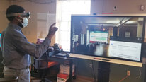
(2) your DIY spectrometer seems amazing! Are the instructions for building this tool available on your site. Could you summarize component parts in accessible terms for folks interested in building their own low cost portable device?
(3) I noticed you implemented programming in a number of contexts. Could you share a bit more about which those were and perhaps why the sites you chose were important. As I think about community labs as informal science learning environments I hoped to learn from your rationale—as to inform my understanding of how these nascent spaces might be important from the perspective of the research team. In other words, what sites did you implement your outreach programs and why?
In any event, thanks for the incredible work in raising public awareness about planet conditions and the power of satellites in informing policy, public decision-making, etc.!
Christopher McGinty
Claudia Bolaños
Ginger Butcher
Communication and Public Engagement Lead
Justice,
Thank you for your interest and comments.
Most of my research has been related to the development of instructional approaches for young learners and content that is often considered too abstract for this audience. Bottomline, while interpreting satellite imagery is abstract, I have been able to teach kindergartners to interpret satellite imagery using interactive media, story, and manipulatives. When it comes to engagement as opposed to formal lessons, I have found content that embed learning objectives within play is most effective at fostering a natural curiosity to investigate more.
The STELLA DIY Spectrometer is currently in pilot-testing stage. We used to employ the Alta Spectrometer in our spectral matching outreach activity. But when these units were no longer being manufactured, we started working on a DIY design. We will be posting the instructions on GitHub. More information will be out this summer.
Regarding selection of locations for our outreach programs, our efforts are primarily connected to NASA supported public events and conferences. We partner with AmericaView to leverage their networks and reach formal education audiences.
Thanks again for your comments. And to learn more about how Landsat data helps inform decision makers, check out our Societal Benefits webpage.
Cheers!
Ginger
Christopher McGinty
Russanne Low
This video is such a celebration- of emerging technologies, of NASA science, and of planet Earth! Great presentation- I'll want to download this and share with the 2022 cohort of SEES Earth System Explorers!
Ginger Butcher
Christopher McGinty
Claudia Bolaños
Justice Walker
Claudia Bolaños
NASA Intern, Landsat Multimedia Outreach Developer
Thank you!! We hope SEES Earth System Explorers enjoys our content, and look forward to their takeaways and feedback.
Christopher McGinty
Justice Walker
Anne Kern
Professor
Excellent overview of the AmericaView and Landsat program. Oh, my goodness, I was just in Lompoc for a visit and recall seeing the wall mural but did not stop! Is it possible to have included a URL or the like for interested folks to follow up? I have known about and used some Landsat data for over 10-years with Native American students to engage them in STEM, but I (and the students) were a bit overwhelmed trying to access and understand that data. It is nice to see that NASA has not given up on engaging the public in understanding the technology. Where do you think Landsat data and technology will fit in the next 25-50 years for use by the general public?
Christopher McGinty
Justice Walker
Claudia Bolaños
Ginger Butcher
Communication and Public Engagement Lead
Anne,
Thanks for your comment and crazy that you just saw the Landsat mural in Lompoc. If you are ever back in the area - be sure to check out our Landsat in Lompoc GeoTour. If you complete all 9 geocaches, you are eligible to get a commemorative GeoCoin (tour ends Sept 2022).
As Landsat data, there are many programs and even research that use Landsat data at the core of their efforts, often so integrated you don't even know it it there - think Google maps. We have thought about doing something like the "Intel Inside" campaign to promote how much Landsat data is the foundation of apps and programs as well as being combined with other data sets. I only see this trend increasing over the next 25-50 years. Check out our Landsat Legacy video series and episode 4 "Plays Well With Others" for more examples of Landsat data being used with other data sets.
Thanks again for your comment.
Cheers!
Ginger
Christopher McGinty
Gerald Knezek
Greetings Peder and all,
Wonderful video! I was especially excited about the segment on STELLA. We have been working with Paul Mirel and others at Goddard on native habit restoration and exploring using STELLA and GLOBE... I wonder if we could involve LandSAT and your project as well? My email is gknezek@gmail.com... would love to talk!
Christopher McGinty
Peder Nelson
OregonView State Coordinator, Land Cover Science Lead for GLOBE Observer, Sr. Faculty Research Assistant, Sr. Instructor of Geography and Geospatial Sciences
Thanks for watching and connecting with us Gerald!
Yes, Landsat would be a great compliment to the ground measurements of STELLA and the GLOBE Program. The measurements from space must be related to what we all see, which is why simply taking photos using the GLOBE Observer mobile app is a really easy way to show the increasing greenness you see with native habitat restoration since when you look at this area from space with Landsat you will probably see a similar greening.
Remote sensing (or measuring things without touching them) can really help show the effectiveness of land stewardship activities....I look forward to following up with you.
Marta Kingsland
Great project!
Christopher McGinty
Peder Nelson
OregonView State Coordinator, Land Cover Science Lead for GLOBE Observer, Sr. Faculty Research Assistant, Sr. Instructor of Geography and Geospatial Sciences
Thanks Marta!
Jonathan Lewis
Inspiring work here! It adds to my dismay that geoscience continues to be a "discovered major" in many universities, and folks are not knocking down the doors to join in. We certainly need broader participation. Recent research points to meaningful (altruistic) work as the leading driver of interest in geoscience study at the undergrad level. I wonder if there are any efforts by the team to focus on environmental justice matters so as to shine light on the relevance of geoscience for many historically excluded communities?
Christopher McGinty
Peder Nelson
OregonView State Coordinator, Land Cover Science Lead for GLOBE Observer, Sr. Faculty Research Assistant, Sr. Instructor of Geography and Geospatial Sciences
Thanks for the important discussion points Jonathan!
There are many of the individual "state"View's which are providing insights into a variety of environmental justice matters since this Landsat perspective provides data and maps that coincide with particular patterns. Trying to broaden participation and interest in these geoscience skills and career opportunities is a primary mission. We invite you to explore and contact the AmericaView network on our website: https://americaview.org/about/
In addition, I find this NASA website to be useful when considering environmental justice: https://earthdata.nasa.gov/learn/backgrounders/...
-Peder
Jonathan Lewis
Further posting is closed as the event has ended.